| |
|
Annex - 7-2
INFORMATION REQUESTED ON SHORE-BASED FACILITIES TO BE MADE AVAILABLE FOR USE IN THE FUTURE GLOBAL MARITIME DISTRESS AND SAFETY SYSTEM (FGMDSS)
|
| |
1. At its fifty-second session the Maritime Safety Committee (MSC 52/28, paragraph 9.27) approved a draft circular (COM 30/ II, annex 2) requesting information on shore-based facilities to be made available for use in the FGMDSS for circulation to Member Governments.
2. At the request of the Maritime Safety Committee the following texts prepared by the Sub-Committee on Radiocommunications at its twenty-ninth and thirtieth sessions are brought to the attention of Member Governments.
1. The definition of A1, A2, A3 and A4 FGMDSS areas, as given in annex 1;
2. the criteria which are intended to assist Administrations when defining the FGMDSS areas, as given in annex 2; and
3. the draft carriage requirements for the FGMDSS, as given in annex 3
3 Taking into account the above and that the draft carriage requirements include both voice communications and DSC facilities for ships sailing in all FGMDSS areas, Member Governments are invited to inform the Organization of the shore-based facilities including NAVTEX which they will make available to provide for the establishment of A1, A2, A3 and A4 FGMDSS areas. |
| |
|
Annex - 1
DEFINITIONS OF THE FGMDSS AREAS
|
1. The FGMDSS areas may be defined as follows:
1. Sea area A1 means an area within the coverage of VHF coast stations providing continuous availability of DSC alerting, as defined by a Contracting Government.
2. Sea area A2 means an area, excluding sea area A1 , within the coverage of MF coast stations providing continuous availability of DSC alerting, as defined by a Contracting Government.
3. Sea area A3 means an area, excluding sea areas A1 and A2, within the coverage of a geostationary satellite providing continuous availability of alerting.
4. Sea area A4 means the remaining sea areas outside sea areas A1, A2 and A3,
2. The FGMDSS areas referred to above, which will be implemented by Administrations, should provide for adequate watchkeeping on relevant distress frequencies, shore-to-ship distress alerting and SAR co-ordinating communications.
3. A1 and A2 areas should be determined by Contracting Governments and notified to the Organisation in sufficient time for circulation of such information to all Contracting Governments. |
| |
|
Annex - 2
CRITERIA FOR ESTABLISHING FGMDSS AREAS
|
1. INTRODUCTION
It is intended that Contracting Governments should use the following criteria as guidance when determining the four mutually exclusive sea areas off their coasts, which are defined in annex 1.
2. SEA AREA A1
2.1. General The communication range of stations operating in the maritime mobile VHF band is likely to be limited by propagation factors rather than lack of radiated power .
2.2. Guidance criteria Sea Area A1 is that sea area which is within a circle of radius A nautical miles over which the radio propagation path lies substantially over water. The radius A is equal to the transmission distance between a ship's VHF antenna at a height of 4 m above sea level and the antenna of the VHF coast station which lies at the centre of the circle.
2.3. Determination of radius A 2.3.1. The following formula should be used to calculate the range A in nautical miles: |
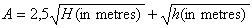 |
| H is the height of the coast station receiving antenna and h is the height of the ship's transmitting antenna which is assumed to be 4 m. 2.3.2. The following table gives the range in NM for typical values of H: |
| H |
50m |
100m |
| for h=4m |
23Nm |
30Nm |
|
2.3.3. The formula given above applies to line-of-sight cases but is not considered adequate for cases where both antennae are at a low level. The range of sea area At should be verified by field strength measurements.
3. SEA AREA A2
3.1. General
3.1.1. Consideration of the reception of radio signals in the 2 MHz band indicates that the range is likely to be limited by propagation conditions and atmospheric noise, which are affected by variations in geographical position and time of day, as well as radiated power .
3.1.2. The theoretical distance to be expected from ground wave propagation can be determined by reference to the "Ground-Wave propagation curves: Sea Water" in CCIR Recommendation 368, adjusted as necessary to take account of the actual radiated field strength from the transmitting antenna and the minimum field strength necessary for the proper operation of a receiver conforming with resolution A.334(IX).
3.1.3 The determination of the minimum signal level required for satisfactory radio reception in the absence of other unwanted signals necessitates account being taken of the noise with which the wanted signal must compete. CCIR Report 322 gives the world distribution of values of noise level and of other noise parameters and shows the method of using these in the evaluation of the probable performance of a radio circuit.
3.2 Guidance criteria Sea area A2 is that sea area which is within a circle of radius B nautical miles over which the propagation path lies substantially over water and which is not part of any sea area A1, the centre of the circle being the position of the coast station receiving antenna.
3.3. Determination of radius B The radius B may be determined for each coast station by reference to CCIR Recommendation 368 and CCIR Report 322 for the performance of a single sideband (J3E) system under the following conditions: |
| Frequency |
2182 kHz |
| Band width |
3 kHz |
| Propagation |
groundwave |
| Time of day |
As in area |
| Season |
As in area |
| Ship's transmitter power (PEP) |
60 watts |
| Ship's antenna efficiency |
25% |
| SIN (RF) |
9 dB (voice) |
| Mean transmitter power |
8 dB below peak power |
| Fading margin |
3 dB |
|
The range of sea areas A2 should be verified by field strength measurements.
4. AREA A3
4.1. Guidance criteria Sea area A3 is the area of the world not being part of any sea area A1 or A2 within which the elevation angle of an INMARSAT satellite is 5 degrees or more.
5. AREA A4
5.1. Guidance criteria Sea area A4 is the area of the world not being part of any sea area A1, A2 or A3. |
| |
| |
| |